
Caminito del Rey: how to get there, where to park and what you will discover along the route
The walkways through the Desfiladero de los Gaitanes lead visitors into one of the most spectacular landscapes in inland Málaga, with cliffs rising up to 300 metres, Mediterranean woodland and wildlife including griffon vultures, eagles and Spanish ibex.
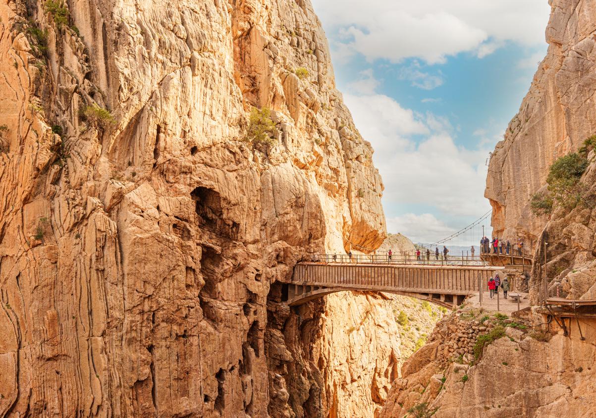

The Caminito del Rey is much more than a walkway attached to a sheer rock face. The route takes visitors through one of the most striking natural landscapes in Málaga province, following the Guadalhorce river between reservoirs, woodland, deep gorges and vertical cliffs that reach up to 300 metres in height.
Located between Ardales, Álora and Antequera, the route crosses the Desfiladero de los Gaitanes Natural Area, a protected landscape whose geology and biodiversity are central to the experience.
The main gorge stretches for around three kilometres and narrows to less than ten metres in some sections.
Before visiting, however, it is important to understand how the route works: the Caminito del Rey is not circular, the entrance and exit are in different places, and reaching the official walkway section requires some walking beforehand.
Where does the Caminito del Rey start and finish?
The route is completed in one direction only, from north to south.
The entrance is located in the Ardales area, while visitors finish in El Chorro, in Álora. This means anyone arriving by car should plan in advance where to park and how to return afterwards.
The official route covers approximately 7.7 to 8 kilometres in total, depending on how the access sections are measured.
The controlled section between the two walkway gates is 2,955 metres long, including approximately 1,550 metres of wooden walkways and another 1,405 metres of paths and forest tracks.
The complete visit generally takes between three and four hours.
How to get there from Málaga
Visitors travelling from Málaga city by car can take the A-357 towards Ardales before continuing along the MA-5403.
The journey is around 59 kilometres and usually takes a little over 50 minutes under normal traffic conditions.
However, reaching the Caminito del Rey area does not mean you have reached the actual entrance.
The official website warns that the site is located in a natural environment and that the final section to the access point must be completed on foot.
From the area around El Kiosko restaurant, there are two main access paths:
- a shorter route of around 1.5 kilometres, taking roughly 20 to 25 minutes;
- a longer alternative of approximately 2.7 kilometres, taking around 35 to 50 minutes.
Visitors should therefore arrive with plenty of time before the entry slot shown on their ticket.
You can also arrive by train
Another option is to travel by rail.
Train services to the area stop at El Chorro-Caminito del Rey station, which is located at the southern end of the route.
From there, visitors need to coordinate their journey with the shuttle bus connecting El Chorro with the northern entrance.
The official organisation recommends checking Renfe timetables, fares and available services for the specific day of your visit.
Where to park if you are travelling by car
One of the easiest options is the Visitor Reception Centre car park.
The currently published price is €2 per day, and parking can be reserved while buying your Caminito del Rey ticket or paid for on arrival, subject to availability.
From there, visitors can take the shuttle bus towards the northern entrance.
The organisation recommends having your vehicle parked at least one hour before your scheduled access time.
There are also parking options close to the northern entrance in Ardales and around El Chorro, near the end of the route.
The best option depends mainly on whether you prefer to use the shuttle bus before or after completing the walk.
The shuttle bus connects the entrance and exit
Because the Caminito del Rey is a linear route, transport between both ends is important for many visitors.
The shuttle bus connects Ardales and El Chorro, allowing visitors to return to the area where they left their vehicle.
The currently published fare is €2.50 per person, separate from the Caminito del Rey admission ticket.
Bus operating times can vary, so checking the latest timetable before travelling is advisable.
A landscape shaped by water and rock
Once inside, the scenery changes constantly.
The first sections pass through areas of Mediterranean vegetation before gradually entering the narrow gorges.
The main geological force behind the landscape is the Guadalhorce river, which carved its way through limestone and dolomite rock over time.
The result is a gorge around three kilometres long, with cliffs reaching up to 300 metres in height and sections where the two rock walls are separated by less than ten metres.
The route passes through areas including the Gaitanejo Gorge, Tajo de las Palomas, Valle del Hoyo and Desfiladero de los Gaitanes, before reaching the final section towards El Chorro.
Pine forests, juniper and riverside vegetation
The vegetation changes depending on altitude, sunlight and proximity to the river.
Typical species in the area include Aleppo pine, stone pine, holm oak, rockrose and Phoenician juniper.
Closer to the river, the landscape becomes greener, with species adapted to wetter environments including reeds, oleander, tamarisk, poplars and willows.
The rock walls are also home to specialised plants capable of growing in cracks and on vertical surfaces, one of the most distinctive environmental features of the Desfiladero de los Gaitanes.
One of the best places to spot large birds of prey
Looking upwards is also part of the experience.
The inaccessible cliffs provide shelter and nesting areas for several species of birds of prey.
Wildlife recorded in the area includes the griffon vulture, golden eagle, Bonelli’s eagle and peregrine falcon.
The higher areas are also home to Spanish ibex, while species associated with the river can be found closer to the water.
The Junta de Andalucía also records the presence of otters in the Guadalhorce, as well as a variety of fish, amphibians and reptiles.
This is one of the reasons why the area is protected for more than just its scenery.
The Desfiladero de los Gaitanes was declared a Natural Area in 1989 and later became part of additional European conservation networks.
How long does the visit take?
Although the famous wooden walkways feature in most photographs, they are only one part of the full route.
The organisation estimates that the complete experience takes between three and four hours, including the access and exit paths.
Visitors must also arrive at the official entrance gate 30 minutes before the time shown on their ticket.
It is worth remembering that this gate is still around a 25-minute walk from the shorter access point near El Kiosko.
Simply calculating the time needed for the walkways themselves can therefore lead to delays.
What to keep in mind before visiting
The Caminito del Rey is located in a natural mountain environment and requires a reasonable level of physical mobility.
Visitors should allow enough time for the access routes and follow staff instructions throughout the experience.
It is also important to check weather conditions and possible closures before travelling, as mountain conditions can affect access.
Children under eight years old are not allowed to enter the Caminito del Rey. Children aged eight and over must be able to prove their age with the appropriate documentation.
Tickets must be booked in advance through the official platform.
Much more than a walkway
The Caminito del Rey is often associated with the dramatic experience of walking along a cliff face high above the river.
But focusing only on that image overlooks much of what makes the route special.
The reservoirs, pine forests, Valle del Hoyo, limestone cliffs and birds of prey circling above the gorge make it one of the most distinctive ways to discover inland Málaga.
And because it is a linear route located in a mountain setting, planning how to get there, where to park and how to return afterwards is almost as important as booking the ticket itself.

Latest news