These hiking trails are some of the best for this time of year in Málaga.
These four hiking trails are perfect for going out in autumn in MálagaThe 35 routes of the Great Trail of Málaga: the treasure is the map itself
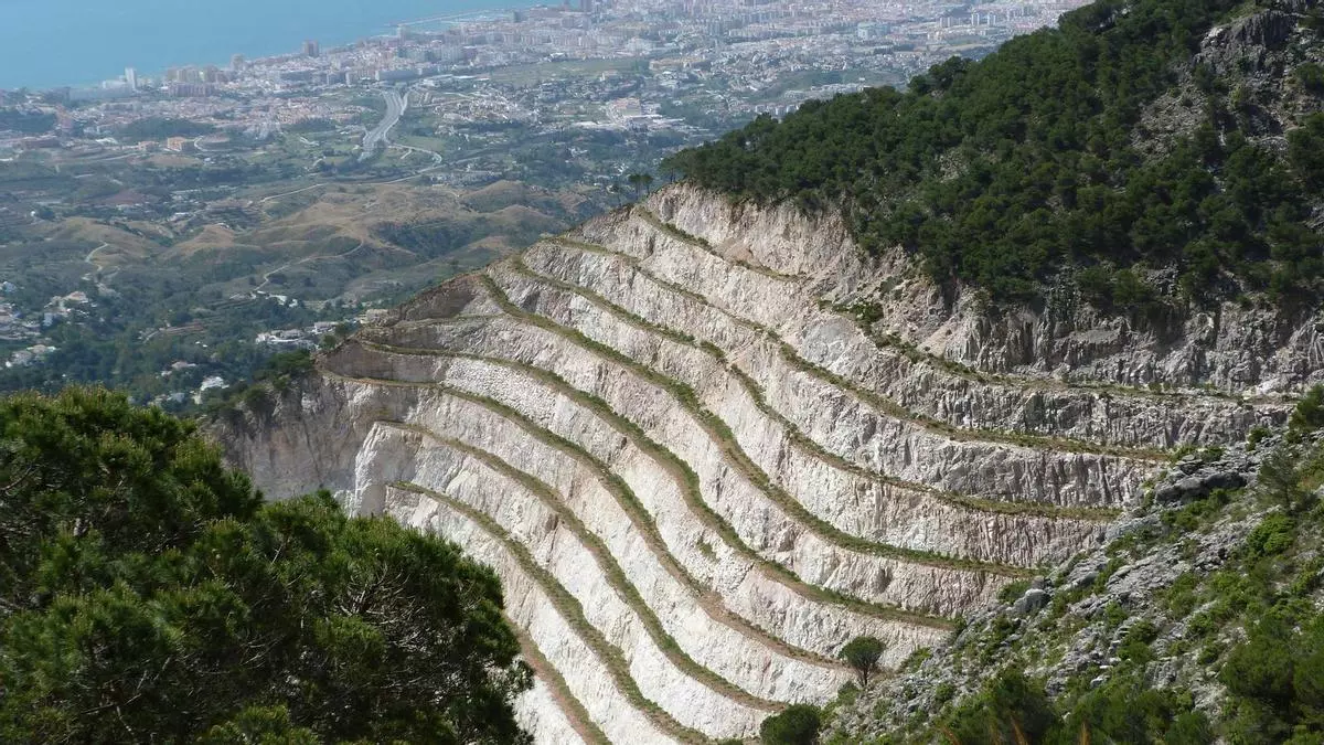

Autumn in Malaga is a perfect time to explore its extensive network of hiking routes. The combination of pleasant temperatures and transforming landscapes makes the province an ideal destination for nature lovers. The Great Path of Malaga, an itinerary that connects the most emblematic points of the province, offers routes adapted to different levels of difficulty and tastes, noted for their scenic and cultural richness. Here we present some of the best options for this season, each with unique characteristics that make them essential.
Each of these routes offers a unique experience, from panoramic views and biodiversity to historical vestiges. The Great Path of Malaga not only connects the most emblematic landscapes of the province but also invites you to discover its cultural and natural richness. Whether you're looking for a relaxed walk between villages or a mountain challenge, these hiking routes are perfect for enjoying autumn in Malaga. With views of the Mediterranean, imposing mountain ranges, and corners full of history, the province offers options for all tastes. Put on your boots, prepare your backpack, and immerse yourself in the beauty of the Great Path of Malaga.
Route between Mijas and Benalmádena
This linear route, 18 kilometers long, connects two iconic municipalities of the Costa del Sol: Mijas and Benalmádena. It is stage 33 of the Great Path of Malaga and has an easy difficulty, perfect for those who want to enjoy a day outdoors without too much physical demand.
The journey begins in Mijas, climbing up a picturesque Via Crucis that leads to the Calvary Hermitage, nestled in the heart of the mountains. This spot is not only a place of great historical interest but also offers exceptional panoramic views, which on clear days reach as far as the coasts of Africa. As we progress, the trail enters the mountains that Mijas shares with Benalmádena, alternating stretches that skirt the boundaries of Alhaurín de la Torre. Finally, the path descends to Benalmádena, completing a day where the mountain and the sea seem to merge on the horizon.
Route from Alameda to Fuente de Piedra
If you are looking for a more extended experience, stage 17 of the Great Path of Malaga, between Alameda and Fuente de Piedra, is an excellent choice. With about 19 kilometers of travel and an estimated duration of 7 to 8 hours, it is a demanding route that crosses the sierras of Camorra and Mollina. Despite its length, its difficulty is low, making it ideal for those who enjoy long but accessible hikes.
The start, in the town of Alameda, places us at a historical crossroads known as loma El Ventorrillo, a point where three municipal terms converge. Throughout the journey, the landscape gradually transforms from the aridity of the sierras to the fertile lands of the Vega de Antequera. The goal at Fuente de Piedra, famous for its lagoon and its colony of flamingos, is a perfect culmination for a day of hiking.
Route from Alfarnatejo to Alfarnate
In stage 10 of the Great Path of Malaga we find a route of 16.6 kilometers that connects the towns of Alfarnatejo and Alfarnate. With a medium difficulty, this hiking route is ideal for hikers with a bit more experience who want to enjoy the rugged landscapes of the Axarquía.
The path begins in Pulgarín Alto, a hamlet of Alfarnatejo, and runs between the Antequera Mountain Range and the depression of Alfarnate. During the journey, the views of the cliffs of Doña Ana and Gomer stand out, as well as the dryland fields dotted with olive trees. The trail skirts the Río Sabar, crossing small bridges and open channels that accompany the walker to Alfarnate. This journey is a unique opportunity to observe native flora, such as holm oaks, gall oaks, and poplars, as well as typical fauna of the Axarquía region.
Route from Villanueva de Algaidas to Cuevas Bajas
For those who prefer shorter routes, stage 15 of the Great Path of Malaga offers a journey of just 10 kilometers between Villanueva de Algaidas and Cuevas Bajas. With a low difficulty and an approximate duration of 3 hours, this route is ideal for beginner hikers or those with limited time.
The trail starts from Villanueva de Algaidas, ascending to the hill of the Cross, a stretch that offers spectacular views of the plains of the Río Genil. Along the route, you pass by the ruins of the convent of Nuestra Señora de la Consolación, built in 1566, and a Mozarabic cave hermitage from the 9th century, adding a historical attraction to this route.

Latest news




Upcoming events
12
Nov
El Desembarco, la traición de Viriato at La Caja Blanca
12
Nov
HOMER El Mero Mero at Sala Trinchera Málaga
13
Nov
Marbella Startup Lab – Innovate & Collaborate
13
Nov
Candlelight: Coldplay & Imagine Dragons at Sala Fundación Unicaja María Cristina
13
Nov
Candlelight: Tribute to Ludovico Einaudi at Anantara Villa Padierna
Similar News

Mijas demands the enclosure of the A-7 walkways due to repeated suicide attempts
Málaga

The announcement by the Díaz brothers opens the Torremolinos Fair tonight.
Málaga

Infinity pool, luxury spa, and grilled lobster: this is how Jennifer Lopez enjoyed her secret getaway in Fuengirola
Málaga