Twelve trails to hike in 2026 in Málaga that traverse protected areas
This hiking calendar invites you to explore lesser-traveled landscapes, paths with history, and locations that reflect the vast natural diversity of the Malaga region.
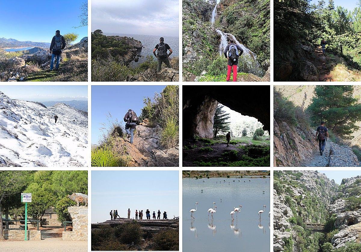

The province of Málaga is a privileged territory for those who enjoy walking through nature. Throughout the year, it is possible to explore some of its most unique protected areas through a selection of twelve routes, one per month, which allow you to delve into different high environmental value enclaves, from natural parks or the only national park in the province to reserves, landscapes, and natural monuments. Here, you can discover vertiginous gorges like the Buitreras del Guadiaro, aerial walkways like the bridge of Saltillo, relic forests of Spanish firs in the Sierra de las Nieves or Sierra Bermeja, or climbs as demanding as La Maroma. A hiking calendar that invites you to explore lesser-traveled landscapes, paths with history, and enclaves that reflect the enormous natural diversity of the Malaga territory. Here are twelve proposals, one for each month of 2026.
This circular route, approved as SL-A-137, travels through one of the most accessible and representative areas of the Montes de Málaga natural park. The itinerary starts from the El Cerrado recreational area and climbs to the Mirador del Cochino, a natural balcony with wide views over the city of Málaga, the Mediterranean, and the surrounding forest. It is just 3 kilometers long, but with a noticeable elevation gain that adds a bit of intensity. It is a medium difficulty route, well signposted and very rewarding to discover the vegetal and landscape richness of the Montes de Málaga in the middle of winter.
Difficulty: Medium
More information: Ruta senderista El Cerrado-Mirador del Cochino (SL-A 137)
This brief itinerary connects two emblematic enclaves of the Yunquera Spanish fir forest, the Puerto del Saucillo and the Cueva del Agua, within the Sierra de las Nieves national park. The route, just two kilometers each way and of low difficulty, runs through a forest of great ecological value, with landmarks such as the Spanish fir of Candelabro and the Chaparrera fountain. Part of the route coincides with the GR-243 and allows you to enjoy a humid and cool environment, especially attractive after winter rains, with the cave as the final point in a setting of great natural beauty.
Difficulty: Low.
More information: Ruta senderista de la Cueva del Agua
This circular route allows you to explore almost all the wetlands that make up the natural reserve of the Lagunas de Campillos, one of the most valuable ornithological spaces in the interior of Málaga. The route, of low difficulty and about 13 kilometers, links several lagoons through dirt tracks and sections of the Gran Senda de Málaga, with an almost flat profile. The itinerary passes through enclaves such as Laguna Dulce, Capacete, Camuñas, or Salada and is particularly attractive in spring, when the water and the presence of birds such as flamingos, coots, or avocets offer their best version.
Difficulty: Low.
More information: Ruta de las Lagunas de Campillos
This itinerary allows you to discover some of the most spectacular waterfalls of the Sierra de las Nieves, in an environment particularly attractive after the winter rains and the early days of spring. The route, approved as PR-A-282, starts next to the Fuente Amargosa spa and enters the riverbed of the Río de los Caballos until reaching landmarks such as the Poza de la Virgen and the Salto de la Rejía, the highest in the province. It is a short route, of medium difficulty, marked by several river crossings and uphill sections, but very rewarding for its landscape, the sound of water, and the natural richness of the Sierra de las Nieves natural park.
Difficulty: Medium
More information: El Sendero de las Cascadas en Tolox con saltos de agua impresionantes (ruta corta)
This linear trail, approved as SL-A-295, allows access to the natural area of Torcal de Antequera from the urban center of Villanueva de la Concepción, crossing one of the most unique karst landscapes in Andalusia. The itinerary, 9.4 kilometers one way, combines lanes and narrow trails until reaching Torcal Alto, passing by landmarks such as the Manuel Grajales viewpoint and the natural monument of El Tornillo. It is a high difficulty route due to its technical sections and elevation changes, but very complete from a landscape, geological, and natural perspective, ideal for enjoying Torcal in spring.
Difficulty: High.
More information: Subida al Torcal de Antequera desde Villanueva de la Concepción
This linear trail, also known as the Red Route, connects two fortified enclaves linked to the Morisco rebellion of 1569 and runs along the ridge of Monte Ariza, in the heart of the Sierras de Tejeda, Almijara, and Alhama natural park. The itinerary starts from the old castle of Lízar and climbs to El Fuerte, one of the last Morisco strongholds in the Axarquía. It is 4.4 kilometers of medium difficulty, with demanding sections and irregular signage, but with constant panoramic views reaching the coast and the Bay of Málaga.
Difficulty: Medium.
More information: Sendero del Fuerte: El camino que une a dos fortalezas con cruentas historias en Frigiliana
This linear itinerary runs along the banks of the Guadiaro river, between the village of Colmenar and the gorge of Buitreras, one of the most spectacular natural monuments in Andalusia. The route, 4.2 kilometers one way and of medium difficulty, advances through lush vegetation until entering a karstic canyon with vertical walls reaching one hundred meters in height. The route allows you to discover landmarks such as the so-called Puente de los Alemanes and offers significant geological and landscape interest, with the usual presence of griffon vultures and other species linked to the river environment.
Difficulty: Medium.
More information: Ruta de las Buitreras del Guadiaro
It is an ideal month to combine hiking and sea in the natural area of the Cliffs of Maro. This non-approved circular route runs through some of the most spectacular enclaves on the eastern coast of Málaga, such as the beaches of Cañuelo and Cantarriján or the cove of La Doncella, as well as old watchtowers that controlled this coastal stretch. It is 6.7 kilometers of medium-high difficulty, with narrow trails and some exposed sections, but with the constant allure of views of the Mediterranean and the possibility of a swim in almost virgin coves.
Difficulty: Medium.
More information: Ruta circular por los Acantilados de Maro: calas paradisíacas, torres vigías y vistas panorámicas al Mediterráneo
This short and simple itinerary allows you to delve into one of the most unique forests in the province, the Spanish fir forest of the natural area of the Reales de Sierra Bermeja. The trail, just one kilometer each way, runs under the shade of the Spanish firs and crosses small streams until reaching the Plazoleta de Genalguacil, where one of the most emblematic specimens of the enclave stands. It is a low-difficulty route, ideal for a peaceful walk, with views of the Mediterranean coast and significant botanical and geological interest, in a protected space unique for its peridotites and endemisms.
Difficulty: Low.
More information: Ruta senderista: Paseo de los Pinsapos de los Reales de Sierra Bermeja
The tenth month of the year can be ideal for exploring the Sierra del Camorro, in Cuevas de San Marcos, when temperatures drop and the autumn landscape enhances the limestone reliefs. This circular trail, integrated into the PR-A-234, runs through the natural monument of the Sierra del Camorro Fault, declared a natural monument, and passes by unique enclaves such as the Cueva de Belda, linked to a well-known local legend, and the Cueva Nueva. It is 6.7 kilometers of medium difficulty, with rocky sections and some demanding climbs, but with wide views and unique geology in the Sierra Norte de Málaga.
Difficulty: Medium.
More information: Ruta de la Sierra del Camorro: El camino que pasa junto a la Cueva de Belda, donde según la leyenda vivía un demonio
This itinerary covers one of the most spectacular sections of the seventh stage of the Gran Senda de Málaga, between Sedella and Canillas de Aceituno, within the natural park of the Sierras de Tejeda, Almijara, and Alhama. The route starts from the recreational area of Sedella and leads to the suspension bridge of El Saltillo along a short but demanding route, 3.6 kilometers one way. It is a high-difficulty trail due to its steep slopes and technical sections with chains, but it offers natural viewpoints, views of the Mediterranean, and an intense experience in one of the most rugged landscapes of the Axarquía.
Difficulty: High.
More information: Sendero de Sedella-El Saltillo: otra forma de llegar al puente colgante
This demanding linear itinerary starts from the urban center of Canillas de Aceituno and climbs to La Maroma, the highest peak in the province of Málaga, within the natural park of the Sierras de Tejeda, Almijara, and Alhama. With an elevation gain close to 1,400 meters and a marked historical character, it follows the old road that led to the snow pits where snow was stored. The route crosses pine forests, high mountain scrub areas, and landmarks such as La Rábita or the Casa de la Nieve. It rewards with landscapes of great beauty and requires experience, good physical preparation, and maximum caution in winter.
Difficulty: High.
More information: Sendero Casa de la Nieve

Latest news




Upcoming events
12
Nov
El Desembarco, la traición de Viriato at La Caja Blanca
12
Nov
HOMER El Mero Mero at Sala Trinchera Málaga
13
Nov
Marbella Startup Lab – Innovate & Collaborate
13
Nov
Candlelight: Coldplay & Imagine Dragons at Sala Fundación Unicaja María Cristina
13
Nov
Candlelight: Tribute to Ludovico Einaudi at Anantara Villa Padierna
Similar News

Málaga Airport Makes History with More Than Three Million Passengers in One Month
Málaga

Port of Málaga looks beyond its docks to support future growth
Málaga
Guide to the Virgen del Carmen Processions in Málaga and the Province
Málaga