A hiking trail to discover the 'eagle' and 'camel' crags that starts from the bluest village in Málaga
The structures you find around this route, shaped over centuries, provide a unique experience in Málaga. This is the best hiking trail in Málaga that you can do in April:
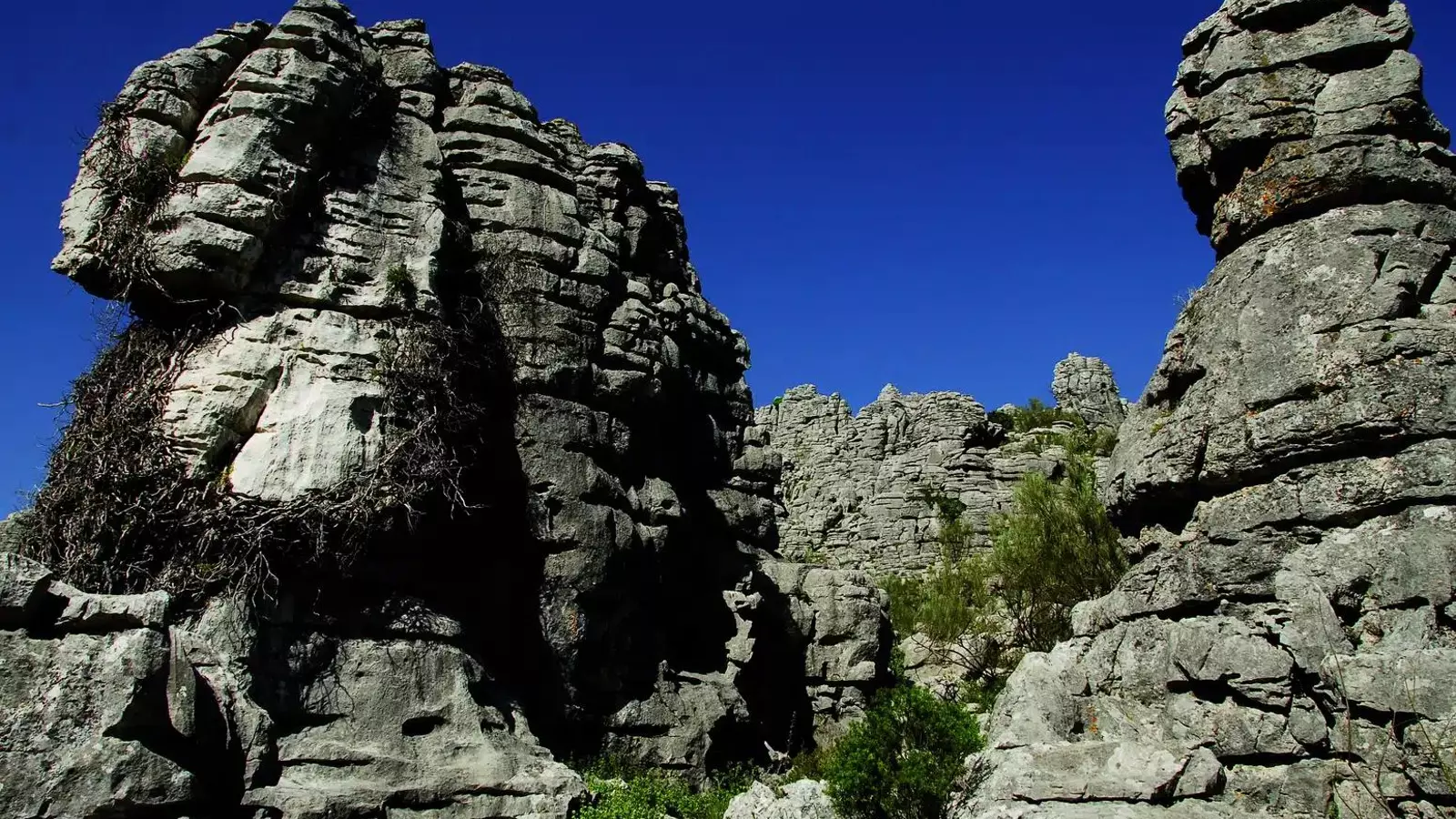

In the heart of the Serranía de Ronda, between the limestone silver of the mountains and the autumnal copper of the chestnut trees, stand Los Riscos, an impressive karstic relief landscape that rises between the municipal areas of Júzcar and Cartajima. This young torcal, shaped by erosion over hundreds of thousands of years, displays a landscape as unique as it is evocative, where nature has sculpted stone figures that spark the imagination of the walker.
Los Riscos are located in the Sierra del Oreganal, about 1,400 meters above sea level, bordering to the north with the Ronda Plateau, to the east with the Sierra de las Nieves, to the south with Sierra Bermeja and to the west with the Guadiaro valley. Its privileged location, in the interior of the province of Málaga, turns this enclave into a true geological museum in the open air.
Natural sculptures in a labyrinth of stone
The trail that delves into Los Riscos begins in Júzcar, the bluest village of Málaga, and is structured around three main alleys that connect with countless ravines, pits, and fissures. The undisputed highlight of the route is the Águila, a large rock whose silhouette resembles a bird of prey scanning the horizon. It is not the only recognizable figure: the Camel, the Lady, the Child, or the Window are some of the formations named by the locals and landowners of the area.
The Águila. / malaga.esThe karstic complex, mostly composed of limestone rocks with high calcium carbonate content, presents a ruiniform aspect, a result of the solvent action of rainwater on the stone. This process has created a rugged terrain with complex orography and great visual contrasts, where each step reveals new forms shaped by time.
Between threshing floors and ancient dry stone constructions
The trail has a marked geological and ethnographic identity. Along the route, ancient human vestiges such as threshing floors and rustic dry stone constructions, integrated into the landscape, can be observed. The ascent begins on a concrete track that crosses landscapes of olive and almond trees, like the China area, and skirts the Fuente de la Castilla and an abandoned quarry that offers broad views of the torcal.
The Águila de Los Riscos. / malaga.esAfter a steep climb, you reach the Puerto de las Eras, the point from which you access the core of the site. Here begins the most demanding section of the route, leading to the Águila. Once this section is overcome, the path becomes smoother, allowing easier progress through the Macoría fortune, where a threshing floor is still preserved, offering wide panoramas.
Powered by WikilocDiverse fauna in a unique environment
The natural richness of Los Riscos is also reflected in its birdlife. During the route, it is possible to spot species such as goldfinches, starlings, hoopoes, black wheatears, or rock thrushes. It is not uncommon to see a bird of prey, like the Bonelli's eagle, or even scavengers like the griffon vulture, soaring among the peaks.
This ecosystem, a result of the interaction between limestone lithology and climate, is part of the extensive geological heritage of the Serranía de Ronda, one of the most complex regions in Europe from a geological point of view. In just 1,260 square kilometers, sedimentary, metamorphic, and igneous outcrops converge, giving rise to unique landscapes like the Cueva del Gato, the Cañón de las Buitreras or the Cueva de la Pileta.
Las formaciones de Los Riscos. / malaga.esThe circular itinerary starting from Júzcar is completed by descending back to the Puerto de las Eras and from there, by the same way back, returning to the starting point on the calle de los Riscos. It is a route of special geological and scenic value, allowing not only the discovery of the whimsical forms of the karst relief but also a piece of the rural history of this mountain range.

Latest news


Upcoming events
12
Nov
El Desembarco, la traición de Viriato at La Caja Blanca
12
Nov
HOMER El Mero Mero at Sala Trinchera Málaga
13
Nov
Marbella Startup Lab – Innovate & Collaborate
13
Nov
Candlelight: Coldplay & Imagine Dragons at Sala Fundación Unicaja María Cristina
13
Nov
Candlelight: Tribute to Ludovico Einaudi at Anantara Villa Padierna
Similar News

Málaga Airport Makes History with More Than Three Million Passengers in One Month
Málaga
Port of Málaga looks beyond its docks to support future growth
Málaga
Guide to the Virgen del Carmen Processions in Málaga and the Province
Málaga