This water tour in Malaga has it all: water, gorges, and a unique experience for any hot day.
A three-kilometer journey through gorges, pools, and crystal-clear waters: El Charco de las Mozas, a key starting point for the aquatic stretch. The complete guide to the 30 natural pools of Málaga for enjoying the most refreshing summer.
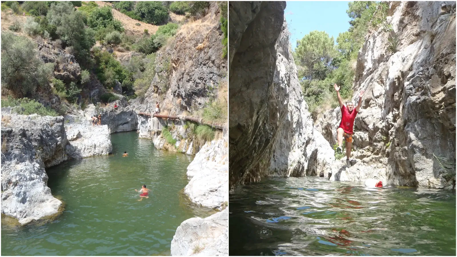

There are paths that are not just walked, they are traversed. Trails where the landscape is not only observed, but envelops the visitor with rock walls, moving water, and filtered light. In the province of Málaga, this type of experience has its own name: the route of the Angosturas del río Guadalmina, a journey where each section transforms the terrain into a succession of sensations linked to water and geology.
Located in the municipality of Benahavís, this route has established itself as one of the most unique trails in the interior of Málaga. With an approximate length of three kilometers, it runs through an environment characterized by limestone formations, Mediterranean vegetation, and the continuous shaping of the Guadalmina River.
The itinerary stands out for integrating different natural elements into a single route: narrow gorges, pools of crystal-clear water, and sections where the riverbed itself becomes the path. This combination makes the route an experience where water plays a leading role from start to finish.
Start of the route: from the hermitage to the Charco de las Mozas
The starting point is located next to the hermitage of Nuestra Señora del Rosario, where there is an area designated for parking vehicles. From this location, the trail moves parallel to the river, offering open views of the surroundings before beginning the descent to one of the most representative places on the route.
The Charco de las Mozas, located beneath the Tajo de los Novios, marks the start of the most characteristic section of the route. In this area, the landscape narrows and the water becomes more prominent. This point acts as a transition between the conventional trail and the aquatic itinerary that defines the rest of the journey.
The Guadalmina canyon: a journey between rock walls
From this point, the route enters a canyon less than a kilometer long, divided into different narrows with their own characteristics. The first section unfolds in a more open environment, where the water usually reaches shallow depths, although the terrain presents slippery surfaces.
The second narrow introduces a notable change in the landscape. The walls rise, and the pools increase in depth, requiring progression through swimming sections. This contrast between passable areas and aquatic sectors defines the dynamic nature of the route.
The third narrow: a space shaped by geology
The most unique section of the itinerary is found in the third narrow. Here, the rock walls barely let light pass through, creating an atmosphere reminiscent of an open cavity. The continuous action of water has led to the formation of calcite deposits, forming interesting speleothem structures.
This sector represents one of the most characteristic moments of the journey, where the combination of narrowness, darkness, and natural shapes creates a sense of isolation within the landscape itself.
Natural obstacles and final transition of the route
After overcoming the narrows, the itinerary reaches a small dam that acts as a natural barrier within the riverbed. This point introduces a new element in the route, where crossing can be done through different options depending on the river flow, including using the rock as a descent surface.
Next, the route enters a final stretch of deep waters that leads to the Charco de los Tubos. This space marks the end of the aquatic journey and the beginning of the exit to dry land.
The return: between irrigation channels and traditional paths
Once the main section is completed, the route continues along an ascending path that leads to an ancient irrigation channel. From this point, the landscape changes perspective, allowing the environment to be observed from an elevated position.
Powered by WikilocThe return to the starting point can be made by following this irrigation channel, crossing narrower zones, or by road, on a more direct route. Both options complete a circular itinerary that combines natural elements and traditional paths.

Latest news


Upcoming events
12
Nov
El Desembarco, la traición de Viriato at La Caja Blanca
12
Nov
HOMER El Mero Mero at Sala Trinchera Málaga
13
Nov
Marbella Startup Lab – Innovate & Collaborate
13
Nov
Candlelight: Coldplay & Imagine Dragons at Sala Fundación Unicaja María Cristina
13
Nov
Candlelight: Tribute to Ludovico Einaudi at Anantara Villa Padierna
Similar News

Málaga Airport Makes History with More Than Three Million Passengers in One Month
Málaga
Port of Málaga looks beyond its docks to support future growth
Málaga
Guide to the Virgen del Carmen Processions in Málaga and the Province
Málaga