The spectacular waterfalls over 20 meters hidden in a small village in Málaga that many hikers visit each spring
The main attraction of the Faraján area is the Las Chorreras de Balastar site, where the stream of the same name plunges in two high waterfalls.
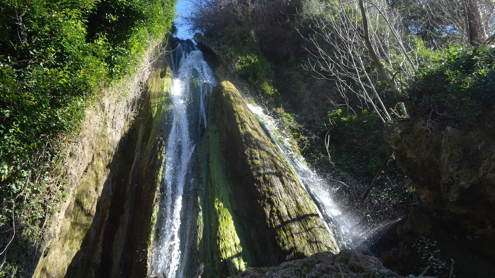

There are places in the province of Málaga that remain discreetly hidden among mountains, far from the most well-known tourist routes. Deep in the Serranía de Ronda, among trails that cross pine forests and ancient agricultural roads, there is a natural enclave that surprises those who venture into it. It is the impressive waterfalls of Las Chorreras de Balastar, a site located in the municipal area of Faraján that attracts numerous hikers each spring in search of nature and unique landscapes.
This natural corner, located right in the Serranía de Ronda, is notable for a series of waterfalls that exceed 20 meters in height and offer one of the most striking natural spectacles in the interior of Málaga. The environment combines native vegetation, traditional trails, and historical remnants that reflect the agricultural and cultural past of the area.
Las Chorreras de Balastar, a natural treasure in the Serranía de Ronda
The main attraction of the surroundings of Faraján is the site of Las Chorreras de Balastar. At this point, the stream Balastar plunges down two high waterfalls that fall between rocky walls and Mediterranean vegetation.
The power of the water, especially after the winter rains, turns this place into an enclave of great scenic appeal. The waterfalls exceed 20 meters in fall, creating a natural scene that has gained notoriety among hiking enthusiasts and explorers of natural spaces in the province of Málaga.During the month of March, the surroundings take on a particularly striking appearance. Mild temperatures favor hiking, and the water flow tends to be more abundant. At the same time, the area's flora begins to bloom, adding green hues and colors that contrast with the rocks and moving water.
A circular route that starts in the village of Faraján
The most common way to discover this enclave is through a circular route that starts in the urban center of Faraján. The trail covers different points of the natural environment while allowing views of the mountainous landscape.
Along the route, ancient hydraulic systems that have been part of the agricultural life of the region for centuries appear. Among them are the traditional irrigation channels that still supply the terraced crops located on the mountain slopes.
Powered by WikilocThese infrastructures have Arab origins and reflect the historical importance of water use in this area of Málaga's interior. Springs and channels carved in stone accompany part of the route, integrating into a landscape dominated by native vegetation.
The ascent to El Romeral and its historical remnants
The tour of the area also offers a variant that leads to the summit of El Romeral, located about three kilometers away. This section adds a historical dimension to the itinerary.
During the ascent, remnants of ancient constructions linked to different historical periods can be found. Among them are vestiges of Celtic origin and a section of Roman wall that testifies to the presence of ancient civilizations in this territory.
From this elevated point, the landscape opens up to various archaeological sites of interest in the surroundings. Among the visible places are the Dolmen of El Romeral and the Cave of the Almendaraches, spaces that add a cultural component to the natural route.
The descent towards the Balastar waterfalls
One of the most notable moments of the itinerary comes when the trail begins to descend towards the stream. The path narrows and winds through the vegetation until reaching the point where the waterfalls are located. In this place, the stream Balastar falls in two water jumps that form the well-known Chorreras de Balastar. The constant sound of water and the humidity of the surroundings create a cool atmosphere that contrasts with the usual dryness of other areas of the province.
Alongside the waterfalls, remains of an ancient Arab mill are also preserved. This building, now in ruins, was part of the traditional hydraulic system of the area. The channels carved in the rock, still visible, were part of the network that distributed water to the agricultural areas. The trail continues following the course of the stream for about a kilometer until it meets the River Genal, one of the main watercourses of the region.
The circular route concludes with the so-called Mill Road, a final stretch that reconnects with the urban core of Faraján after covering about three additional kilometers.
This last segment allows a renewed view of the rural landscape of the surroundings, where terraced crops, pine forests, and traditional trails that have been used for generations by the inhabitants of the area are combined.

Latest news




Upcoming events
12
Nov
El Desembarco, la traición de Viriato at La Caja Blanca
12
Nov
HOMER El Mero Mero at Sala Trinchera Málaga
13
Nov
Marbella Startup Lab – Innovate & Collaborate
13
Nov
Candlelight: Coldplay & Imagine Dragons at Sala Fundación Unicaja María Cristina
13
Nov
Candlelight: Tribute to Ludovico Einaudi at Anantara Villa Padierna
Similar News

Málaga Airport Makes History with More Than Three Million Passengers in One Month
Málaga
Port of Málaga looks beyond its docks to support future growth
Málaga

Guide to the Virgen del Carmen Processions in Málaga and the Province
Málaga