The 13 Natural Monuments of Málaga and Routes to Reach Them (Most Are Simple)
Gorges, caves, springs, and even a very ancient tree are part of this list of exceptional places in the province.

Malaga is the smallest province in Andalusia, but it also has the most natural monuments in the region. This is a striking lead when compared to the rest of the provinces: Almeria follows with 11, while the other Andalusian provinces have between three and eight. The status of natural monument, regulated by the Andalusian Regional Government, protects areas that stand out for their uniqueness, rarity, or exceptional beauty, whether they are geological formations, river sources, unique forests, or sites of great speleological and scenic interest.
Their distribution on the map of Malaga is also revealing: all the official regions of Malaga have at least one natural monument except for Guadalteba. However, the distribution is uneven. Almost half of the thirteen natural monuments are concentrated in the Serranía de Ronda, where the Cueva del Hundidero, the Cueva del Gato, the source of the Genal River, the Tajo de Ronda, the Buitreras del Guadiaro and the Pinsapo de las Escaleretas are located. The rest are distributed between the Axarquía, the western Costa del Sol, the Sierra Norte de Málaga, the Guadalhorce Valley, and the Antequera region.
They form a diverse catalog: from iconic rocks such as the Tornillo del Torcal, to water sources such as the Cien Caños, to coastal dunes, river gorges, underground caves, historic viewpoints, and emblematic peaks such as Jabalcuza. This group could be expanded if the request for the Castaño Santo de Istán to also be declared a natural monument is successful.
Between the Iznájar reservoir and Cuevas de San Marcos stands the Falla de la Sierra del Camorro, one of the most unique geological sites in the province. This karst massif is over 900 meters high and stands out for its vertical cliffs, formed in the Jurassic period, which rise above a sea of olive groves. Inside is the Cueva de Belda, a cave of great scientific interest whose access is restricted and only allowed at certain times of the year to protect the colony of bats that inhabit it. In the upper area, there are also remains of the ancient medieval city of Belda. This natural monument stands out for clearly showing the tectonic history of central Andalusia. Its steep walls reveal the contact between fractured limestone blocks and are home to flora and fauna adapted to shady and steep environments. The fault is accessible from several points and offers perimeter routes to contemplate its magnitude without compromising its ecological balance. The combination of rock, landscape, and medieval history makes it one of the most unique enclaves in the north of the province.
In the heart of the Alcojona Spanish fir forest, in the Sierra de las Nieves, stands the Pinsapo de las Escaleretas, the only tree in the province classified as a natural monument. Over 26 meters tall and with a crown that casts almost 200 m² of shade, it is estimated to be between three and four centuries old. Its imposing stature and its location in one of the best-preserved Spanish fir forests explain its importance and why it has been protected for decades.
This specimen sums up the extraordinary botanical importance of the species, a relic of the forests that populated the south of the peninsula in colder times. Next to it is the tree known as Falsa Escalereta, which is similar in size, often causing confusion. Its declaration protects both the tree and the ecosystem that surrounds it, which is key to understanding the natural identity of the Serranía de Ronda.
The Artola Dunes, also known as the Cabopino Dunes, are one of the last well-preserved dune systems on the Costa del Sol. The landscape combines shifting dunes, psammophilous vegetation, and wooden walkways that allow visitors to explore the area without damaging its fragile balance. This dune system is a remnant of the large chain that once occupied more than 20 kilometers of coastline. The enclave is also home to the Torre de los Ladrones, a Site of Cultural Interest, which adds significant historical value. Its declaration as a natural monument protects both the dune dynamics—key to slowing marine erosion—and the coastal biodiversity that inhabits this unique environment.
Igualeja is home to the spectacular source of the Genal River, where water flows from a cavity to form a large pool of crystal-clear water. Although the Genal receives contributions from municipalities such as Júzcar, Cartajima, and Faraján, this point is the most emblematic and accessible for observing the beginning of the river's course.
The enclave stands out for its hydrogeological value and for the beauty it retains despite its accessibility. The purity of the water, the riverside vegetation, and the distinctive character of the Genal justify its classification as a natural monument. A visit is especially recommended in autumn and spring, when the flow is greater.
The Tajos del Alcázar form one of the most rugged reliefs in the Sierras de Tejeda, Almijara, and Alhama Natural Park. Its vertical walls, largely inaccessible, have allowed the preservation of an ecosystem where mountain goats and several species of birds of prey stand out. From the Alcázar recreation area, you can see the magnitude of the main gorge and the riverbed.
Its designation as a natural monument protects an enclave of great geological and scenic value. Its walls, eroded over millennia, show the force of the natural processes that have shaped this sector of the mountainous Axarquía region.
In the heart of the Torcal de Antequera is El Tornillo, a rock whose shape resembles a screw and which has become the emblem of the area. Its structure shows the superimposition of marine strata deposited millions of years ago and subsequently shaped by erosion.
This natural monument is essential for understanding the karstic geology of the Torcal, one of the most important landscapes in Europe. Its fragility led to the adoption of protective measures to prevent direct contact.
Las Buitreras del Guadiaro is one of the most spectacular gorges in Andalusia. The river has carved out a gorge with walls over 100 meters high and, in some sections, barely a meter wide. The erosive force and verticality of the walls create a landscape of enormous visual impact.
Its geological uniqueness and its function as a biological corridor explain its protection as a natural monument. It can be viewed from the higher areas or from the Puente de los Alemanes bridge, always taking extreme precautions.
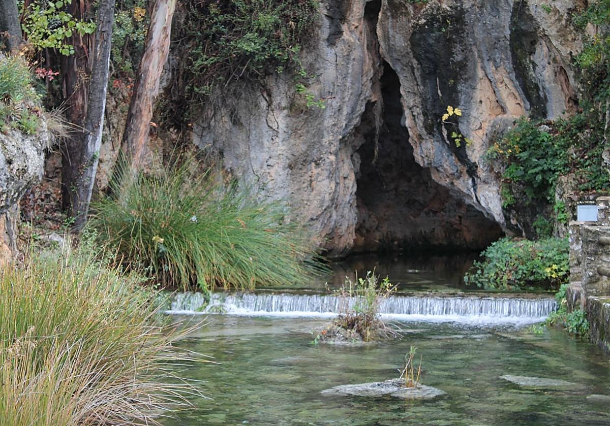
The Cueva del Gato (Cat Cave) is one of the natural symbols of the Serranía de Ronda. Its mouth, crowned by a permanent waterfall, is one of the most recognizable images of Malaga. It is part of the underground system of the Gaduares River, which runs for more than four kilometers before joining the Guadiaro.
Recent rains and the relief of the Los Caballeros reservoir have restored this system to its maximum splendor, with a reactivated interior flow and a highly transparent exterior pool. Access to the interior is regulated, but the external area offers a landscape of enormous speleological value.
Hiking trail: You can walk down from the parking lot.
The Mirador del Guarda Forestal (Forest Ranger's Viewpoint), inaugurated in 1977, is a tribute to the centenary of the Forest Ranger Corps. The sculpture by Enrique Arrenberg, depicting a ranger pointing to the horizon with a child, symbolizes the transmission of respect and environmental education.
At an altitude of around 900 meters, it offers one of the most complete panoramic views of the Turón valley and the heart of the Sierra de las Nieves. A cobbled path surrounds the sculpture and allows for an interpretive visit of the enclave.
Hiking trail: You can walk there from the parking lot.
The Fuente de los Cien Caños (Fountain of a Hundred Spouts) is one of the most representative springs in the province. Its aligned jets mark the source of the Guadalhorce River. The contrast between rock, water, and vegetation makes this enclave one of the most emblematic landscapes of the Sierra Norte.
Its seasonal nature means that it regains its full force after the first rains. This is the starting point for the Ruta de los Nacimientos, an easy trail that connects other points where water emerges.
The Cueva del Hundidero is one of the most breathtaking entrances to the karst system of the Serranía de Ronda. The Gaduares River submerges here to begin an underground journey that culminates in the Cueva del Gato cave.
Recent rains reactivated the internal flow of the system by releasing large volumes of water from the Los Caballeros reservoir into the galleries. Its declaration protects one of the most remarkable geological enclaves in the province.
The Tajo de Ronda is one of Spain's most iconic urban and natural landscapes. Carved out by the Guadalevín River, it is over 100 meters deep and crowned by the Puente Nuevo bridge. Its visual impact has made the gorge an international symbol. In recent years, access has been enhanced by the Camino del Desfiladero del Tajo, a route with walkways and specially prepared sections that allow visitors to enter the gorge and observe its walls from within. This project, developed in phases, has received thousands of visitors and has highlighted the geology, hydraulic heritage, and magnitude of the relief.
Hiking trail: Desfiladero del Tajo or Sendero Asa de la Caldera – Los Molinos del Tajo
Pico Jabalcuza is one of the most recognizable peaks in the Guadalhorce Valley. Its proximity to the town of Alhaurín de la Torre and its silhouette, visible from much of the metropolitan area, have made it a landmark in the landscape. Its summit, at over 600 meters, offers sweeping views of the Malaga coastline, the Sierra de Mijas, and the mouth of the Guadalhorce River. The massif is home to holm oak forests, mastic trees, thyme fields, and remarkable fauna associated with rocky environments. It is a popular spot for local hikers and one of the most significant natural enclaves in the region.
*Most hiking trails are currently open, although in exceptional circumstances the authorities may restrict access to them for the safety of walkers. It is advisable to check their status before setting out on these trails.

Latest news



Upcoming events
12
Nov
El Desembarco, la traición de Viriato at La Caja Blanca
12
Nov
HOMER El Mero Mero at Sala Trinchera Málaga
13
Nov
Marbella Startup Lab – Innovate & Collaborate
13
Nov
Candlelight: Coldplay & Imagine Dragons at Sala Fundación Unicaja María Cristina
13
Nov
Candlelight: Tribute to Ludovico Einaudi at Anantara Villa Padierna
Similar News

Málaga Airport Makes History with More Than Three Million Passengers in One Month
Málaga

Port of Málaga looks beyond its docks to support future growth
Málaga
Guide to the Virgen del Carmen Processions in Málaga and the Province
Málaga