Route of the Júzcar Mills: a thrilling trail with a suspension bridge that even children can tackle
This circular route, which is less than a kilometer and a half long, passes by the spectacular Birth of the Zúas.
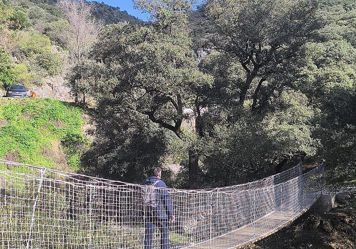

A circular marked trail that starts from the urban area of Júzcar (Los Molinos street) and goes through the environment of the Riachuelo stream up to the Source of ... Las Zúas.
-
Trail Information
Region: Serranía de Ronda
Municipality: Júzcar
Difficulty Level: Low. Although the route is very short, it includes a steep ascent and descent, which should be considered if going with small children who are not used to such slopes. Some sections may be slippery due to moisture or overflowing water after recent rains.
Type of Route: Circular
Approximate Duration: 40 minutes
Length: 1.38 kilometers
Minimum Altitude: 581 meters
Maximum Altitude: 634 meters
Nearby Points of Interest: Old mills, Riachuelo stream, suspension bridge, source of Las Zúas, Chorro de Trujillo spring, Church of Santa Catalina, Old Tin Factory Winery (wine tourism) and Sima del Diablo, a place for beginners in hiking with active tourism companies.
Expand
Source of Zúa J. Amellones-
How to Get to the Starting Point
The route begins at one of the entrances to the urban area of Júzcar. Specifically, look for Los Molinos street, where the descriptive sign for this itinerary is located. Parking is available at the entrance of the village or in designated areas inside. If not, the route can start near the municipal pool and Chorro Trujillo, where some parking spots are available. It's only about 200 meters walk to the village entrance.
-
Route Description
1The journey begins in the urban area of Júzcar, descending Los Molinos street, so that the cemetery and the Church of Santa Catalina are on the left. This first urban section is clearly downhill. Within a few meters, you reach a viewpoint that overlooks the mills that give the route its name and the Riachuelo stream, a tributary of the Genal. Next to them, there are sculptures of wild boars and a traffic light that will delight the little ones.
Expand
Wild boar sculptures next to the Los Molinos viewpoint J. Amellones2From the Los Molinos viewpoint, one of the most demanding parts of the trail begins. In this case, it's not an ascent but a descent. The last section has a very steep slope where caution is needed. Afterwards, when you reach the river, the cobblestone path may be wet or even flooded after days of intense rain. This leads to the area known as Los Molinos, with centuries-old buildings and a bridge that seems medieval. This bridge must be crossed to continue the path.
Expand
Riachuelo stream next to Los Molinos J. Amellones3After crossing the bridge, you start to ascend while leaving the Los Molinos area behind. Another demanding section due to its slope, but this time uphill. It's just a few meters until you leave the rural area behind and connect with a wide path in a shady area of cork oaks, from where you can see a few meters away what is known as the source of Las Zúas.
Expand
You have to cross this stone bridge J. Amellones4Without leaving the main track, you reach a suspension or Tibetan bridge, one of the most photogenic elements of the route. It is a stable and well-maintained step that connects both sides of the valley. Once crossed, you continue along a trail with a gentle ascent for a few meters until you reach a well-marked crossroad. To the right, a detour of just 60 meters leads to the Source of Las Zúas, a constant spring that emerges among the rocks. It is considered one of the sources of the Genal River, and some even claim that it contributes the most to it. The damp and shaded enclave features notable riparian vegetation, with small but intense waterfalls.
Expand
Tibetan bridge in the last meters J. Amellones5After visiting the source, you return to the main path, continuing with a gentle ascent until you connect with the MA-7301 road. Before that, you must pass through a narrow passage next to a metal gate. Thus, you will see the sign indicating to continue towards the entrance of the village and the starting point of this route. Before that, you will pass by the Chorro Trujillo spring and the municipal pool. You should walk on the left side of the shoulder, which allows you to see the vehicles driving on that road.
Expand
Last meters before reaching the village. J. AmellonesFlora and Fauna
The environment is dominated by cork oaks and holm oaks, with an abundance of chestnut trees on the nearby slopes. Along the margins of the stream and at the source, riparian vegetation appears, featuring oleanders and other plants associated with wet areas. Among the fauna, raptors flying over the valley and the regular presence of wild boars, as well as small mammals typical of this ecosystem, stand out.
Expand
Cork oaks and holm oaks abound on this route J. Amellones
Latest news




Upcoming events
12
Nov
El Desembarco, la traición de Viriato at La Caja Blanca
12
Nov
HOMER El Mero Mero at Sala Trinchera Málaga
13
Nov
Marbella Startup Lab – Innovate & Collaborate
13
Nov
Candlelight: Coldplay & Imagine Dragons at Sala Fundación Unicaja María Cristina
13
Nov
Candlelight: Tribute to Ludovico Einaudi at Anantara Villa Padierna
Similar News

Málaga Airport Makes History with More Than Three Million Passengers in One Month
Málaga

Port of Málaga looks beyond its docks to support future growth
Málaga

Guide to the Virgen del Carmen Processions in Málaga and the Province
Málaga