

How to Climb La Maroma and La Torrecilla, the Two Highest Peaks in Málaga
To reach the highest peaks, one must face routes of great difficulty in any case, for which good equipment and mountaineering experience are recommended.
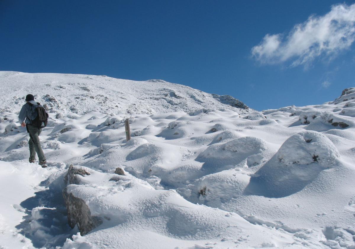

With the recent winter snowfalls, many people want to visit and see a white blanket of snow. The two safest spots, as usual, are the two highest peaks in the province of Málaga, La Maroma, commonly known as Tejeda Peak, and (La) Torrecilla*. In any case, these are complex accesses, requiring significant physical effort due to the elevation gain (over a thousand meters in the best cases).
Besides effort, it requires time, since depending on the pace and the chosen route, it can take between 3 and 6 hours just for the ascent. Therefore, it is necessary to start early so that you don't get caught by nightfall on the way back.
Moreover, in addition to some experience in mountain climbing, appropriate equipment is necessary. This is especially important considering that part of the walk will be on snow. Suitable boots for snow and trails, mountaineering clothing, hats, or sunglasses are essential.
It is also important to carry enough water and high-calorie foods, such as nuts, energy bars. You can also bring sandwiches and fruit.
It is highly advisable to carry maps, either on paper or digitally. These can be viewed on mobile apps like Wikiloc. Therefore, it is mandatory to carry a phone with enough battery life for the duration of the route.
Also, pack plenty of common sense, as it is best to turn back and give up the attempt in the face of any adversity or physical discomfort.
Considering all this, the possible routes for each of the peaks are as follows.
Ascent from El Robledal (Alhama de Granada). This route is the least physically demanding (one thousand meters of elevation gain), but that doesn’t mean it's easy, as there are some complex sections with ice patches. This is the case in the area known as El Salto del Caballo, where you can slip if you do not have the appropriate equipment. A fall with that elevation gain would lead to a very serious problem. This route starts from the recreational area of El Robledal, that is, on the north face of Sierra Tejeda.
More information about the route
Ascent from El Alcázar (Alcaucín). With slightly more difficulty than the previous one, this route starts at the recreational area of El Alcázar. At the top of this area, which is included within the natural park of the Sierras de Tejeda, Almijara, and Alhama, begins a tough ascent, with more than 1,200 meters of elevation gain over more than ten kilometers (one way only).
More information about the route
Ascent from Canillas de Aceituno (Snow House Trail). This is probably the most well-known route to La Maroma. It starts next to the Town Hall of Canillas de Aceituno, in the center of this town in the Axarquía. The start is already tough, as there is a steep climb up to the area known as La Rábita. After that, there is a lighter section, where you can physically recover before tackling the tougher sections ahead. This route has an elevation gain of approximately 1,400 meters, which is covered in almost 8.5 kilometers (one way only).
More information about the route
Ascent from Sedella. This is the most complex ascent of all and probably the least known. Although the elevation gain to be faced is slightly less than that from Canillas de Aceituno, it is an equally physically demanding route that has the added difficulty of sparse signage. Therefore, this route is not advisable for those who have not previously climbed La Maroma by the other trails.
Ascent from Puerto del Saucillo or from the Luis Ceballos viewpoint (Yunquera). From the municipality of Yunquera, there are two great options for ascending the highest peak of the Sierra de las Nieves. You can choose between Puerto del Saucillo or El Caucón (Luis Ceballos viewpoint), which are accessed by a dirt track that later forks to reach each of them. However, it is important to note that authorities may temporarily close access to these roads to vehicles, either due to the expectation of many cars in the area or due to snowfall. This would mean an added effort to reach any of the two starting points. Whether starting from El Saucillo or El Caucón, both paths meet at Peñón de Enamorados. From there, a path with little elevation gain leads to the foot of La Torrecilla, known as El Pilar de Tolox. From there, a final great effort is required to reach the summit, as there is an elevation gain of almost 250 meters in just one kilometer. From Puerto del Saucillo to the summit, there is an approximate elevation gain of 700 meters and a length, one way only, of 8.5 kilometers. Additional walking may be required to reach the starting point. You can also access from other locations, such as the town of El Burgo, passing through Peñón de Enamorados.
More information about the route
Ascent from Los Quejigales. This is probably the most popular route. It starts at the recreational area of Los Quejigales, which is accessed by a dirt track. This can be partially muddy. It can even be closed beforehand by the authorities to prevent congestion in the area or in anticipation of snowfalls. In any case, if you reach Los Quejigales, you must face two relatively demanding sections. One is at the beginning and the other at the end, as it also reaches El Pilar de Tolox, just like the previous route. In total, the elevation gain from Los Quejigales to La Torrecilla slightly exceeds 700 meters over a total of 7.5 kilometers (one way only).
Ascent from Tolox. Like the ascent from La Maroma or Tejeda Peak from Sedella, this is the least known and least recommended for those who have not made the previous ascents to Torrecilla. If done from the village, you must face an elevation gain of almost 1,600 meters above sea level. This is coupled with the complexity of the route, with very tough sections where it is not always easy to find your way. With snow, the situation worsens.
*Although today it is known as Torrecilla, its origin obviously carries the feminine article. In fact, according to Rafael Flores, a guide from RF Natura and an expert connoisseur of these peaks, its original name would be Cerro de las Plazoletas. La Torrecilla would correspond, according to this thesis, to Peñón de los Enamorados, which does have the shape of a tower.

Latest news



Upcoming events
17
Sep
La Pequeña Cuba Gastro-Cultural Festival in San Pedro Alcántara 2026
18
Sep
World Wellness Weekend Marbella 2026
18
Sep
Candlelight: Queen vs. ABBA in Málaga
18
Sep
Candlelight: Coldplay and Imagine Dragons in Málaga
18
Sep
3 de Corazones – Pancho Céspedes, Enrique Ramil and José Luis Jaén in Málaga
Similar News
Málaga Airport Makes History with More Than Three Million Passengers in One Month
Málaga

Port of Málaga looks beyond its docks to support future growth
Málaga
Guide to the Virgen del Carmen Processions in Málaga and the Province
Málaga