

Spectacular water births and waterfalls in Málaga after recent rains
From the Guadiaro Valley to the Cliffs of Maro, there is an exciting journey through springs and waterfalls that show their best side after the recent rainfall.
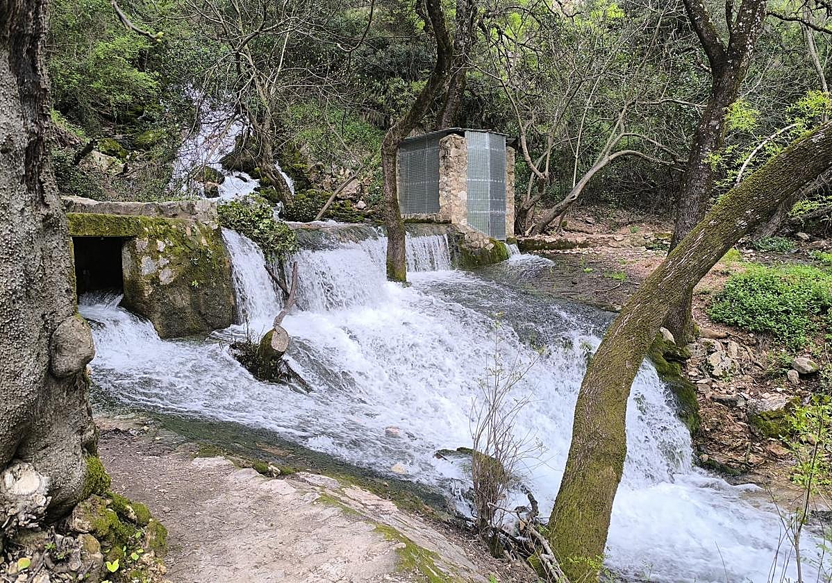

The rains of recent weeks have brought water back to the forefront in many parts of the province's interior. Springs that ‘break’, waterfalls that only appear in generous winters, and waterfalls that completely transform the landscape offer scenes that are difficult to see in dry seasons. From the Serranía de Ronda to the Axarquía, passing through the Sierra de las Nieves or the Guadalhorce Valley, this route brings together some of the most spectacular water features in Malaga, accessible on foot, linked to hiking trails or, in very specific cases, even from the sea. A fleeting natural spectacle that invites you to explore the province. Most of these sites are easily accessible, although in some cases they involve hiking trails.
It is one of the most spectacular in the province of Malaga after heavy rains. A semicircular waterfall located in Estación de Benaoján, which can be reached fairly easily on foot. In fact, it is located behind a well-known hotel, Molino del Santo (which is usually closed during the coldest months of the year. In winter, if you go very early or very late, you may encounter thick fog. Although some people call it Cascajales, its correct name is Nacimiento de Benaoján. Its waters flow directly into the Guadiaro River after passing through the center of Estación de Benaoján.
Nearby hiking trail: Benaoján-Jimera de Líbar Station
After heavy rains, it shows its best side. Fortunately, this is usually the case at certain times of the year, such as winter and spring. In this case, it is located in the municipality of Jimera de Líbar, next to the Guadiaro River and in the rural center of the station. In this case, you will have to walk a little further to get there. To do so, you will first have to take the MA-8307 road, almost to the end. After crossing the bridge over the Guadiaro River, before joining the road that connects Jimera with Cortes de la Frontera and Benaoján, you will have to turn right and look for parking in the area. Then you will have to walk westward, with the Guadiaro River on your right. First, you will walk along a lane in a residential area. Then, after passing one of the houses along a narrow path, you will join a slightly wider lane that runs parallel to the river until you reach the source of the Artezuelas, located almost 1.5 kilometers from the starting point. Its waters flow directly into the Guadiaro.
Nearby hiking trail: Caminos de las Orquídeas (Orchid Trails): Trails to enjoy the spring blossoms
It is the best known in the Serranía de Ronda and, although it has been practically dry in some autumns, in recent weeks it has been truly spectacular. Although this area, which is a natural monument of Andalusia, is officially called Nacimiento del Genal, it is by no means the only important source of water for this river. In fact, it is the sum of several streams that converge between Júzcar, Parauta, Pujerra, Cartajima, and Faraján. However, it is the most emblematic place in Alto Genal, as it is located at the entrance to Igualeja and has a spacious recreational area that is particularly beautiful between autumn and spring thanks to its trees. It is very easy to reach by car.
Nearby hiking trail: Sendero de las Caleras
In the lower part of the village of Faraján, you can see two striking waterfalls, known as the ‘chorreras’ de Balastar, the name given to an ancient Arab settlement that has now disappeared. Both waterfalls are easily reached from the town center. The first one is just over half a kilometer away on foot. Sometimes these waterfalls may appear dry, but this is not because of a shortage of water, but because it has been temporarily cut off for the irrigation of the orchards in the area.
* In this region, you can also visit the Nacimiento de las Zúas, the Sinaí waterfall, and the Sima del Diablo (canyoning), all of which are in Júzcar, or the Guadalevín waterfalls below the Puente Nuevo de Ronda.
In this village in Guadalteba, the Salto del Cao and the Nacimiento are part of the same low-difficulty circular route that makes water the main attraction. The route starts at the Nacimiento itself, one of the springs that feed the Cueva River and which usually has a good flow for much of the year. In addition, after heavy rains, the locals say that it ‘breaks’, meaning that it flows with great vitality. From there, the trail enters a pleasant riverside section until it reaches the old flour mill and the Cao waterfall, which is particularly spectacular after heavy rains. It can even be seen from the A-367 highway. Both sites are part of an easy walk, very close to the town center, ideal for enjoying the local hydraulic heritage.
This well-known spring is once again showing its most spectacular image these days after the recent rains, with an abundant flow that gushes forcefully from the aquifers of the Sierra de San Jorge. Located in the natural surroundings of the Sierra de Camarolos, this site is considered one of the great springs of the province and is pointed out by many as the unofficial source of the Guadalhorce River (the official source is on the other side of the mountains, in the province of Granada). In 1985, the spring was transformed into the current monumental fountain, consisting of a hundred—or even a hundred and one—spouts. Declared a natural monument of Andalusia, it is also the starting point for several hiking trails and a very popular spot in winter and spring due to the force and spectacle of the water.
Also known as El Chorro, this spring is one of the most notable karstic springs in the Sierra de Camarolos, in the municipality of Villanueva del Rosario. Water flows from its hillside, supplying the village and the surrounding irrigated areas, and is distributed at various points depending on the water table of the aquifer. This natural discharge of water is best appreciated after episodes of rain, when the flow is more lively and visible. The enclave, accessible on foot via a lane from the Rosario chapel, stands out for its forest environment and its essential role in local hydrology, making it a very attractive destination for hikers and nature lovers.
* In this region, you can also visit the source of the Río de la Villa in Antequera.
These two sites form one of the most spectacular waterfall complexes in the Sierra de las Nieves, within the municipality of Tolox. La Rejía, with a 51-meter drop, is considered the highest waterfall in the province of Málaga and is at its best between autumn and spring, after periods of heavy rainfall. Nearby, on the Caballos River, the Poza de la Virgen completes this beautiful river enclave. Both can be seen from the Sendero de las Cascadas (PR-A-282) trail, a route that allows you to enjoy the moving water in one of the most unique landscapes in the national park.
Among the tributaries of the Grande River is the Jorox, named after the village of Alozaina that it flows through. Along this route, the river has a spectacular waterfall, which has attracted many canyoning enthusiasts for years. You don't have to take part in this dizzying outdoor activity to see this waterfall. All you have to do is walk down a steep path from the entrance to the village. In just five minutes you can reach the foot of this waterfall in the Sierra de las Nieves region.
This is one of the most unique river enclaves in the Guadalhorce Valley and these days it is once again particularly spectacular thanks to the increased flow of the Alaminos River after the recent rains. This natural monument, protected as a Site of Community Interest and declared a unique spot by the Provincial Council, combines waterfalls, small cascades, and pools nestled between limestone rocks and peridotite outcrops. Located at the confluence of Coín, Mijas, and Alhaurín el Grande, it can only be accessed on foot, which helps to preserve an area of great geological, scenic, and ecological value that is now regaining some of its natural spectacularity.
* In these regions, you can also visit the springs and waterfalls of Turón and Fuensanta, in El Burgo, or the source of the Grande River, in Yunquera, among others.
It is one of the most striking water features in the Axarquía when the rains have been generous, but also one of the most secluded. However, getting there is now easier thanks to stage 8 of the Great Málaga Path. This spring flows in the municipality of Canillas de Aceituno, on the southern slope of the Sierra de Tejeda, and gives rise to a stream that descends between limestone walls and riverside vegetation. After episodes such as the Francis storm, the water gushes forth with force and turns the surroundings into a small natural spectacle, closely linked to local trails and ancient hydraulic infrastructures that recall the historical importance of this river for the area.
It is one of the most striking waterfalls on the eastern coast of Malaga when there are episodes of heavy rain. This enclave, declared a unique spot by the Provincial Council, is located in the municipality of Nerja, very close to the town of Maro and in the surroundings of the natural landscape of the Maro Cliffs. The waterfall is formed by the natural drainage of several ravines and, after the latest rainfall, it presents a powerful and continuous waterfall that contrasts with the abruptness of the cliffs. To see it up close, unlike other sites on this list, you don't need to find a trail, but rather a kayak. It can also be seen from a distance from different locations near this protected area.
* In this region, you can also see the source of the Guaro River, in the territory of Periana, when it breaks, the waterfalls of the Alcázar stream (Alcaucín) or the waterfall of the Torrox or Patamalara River.

Latest news




Upcoming events
17
Sep
La Pequeña Cuba Gastro-Cultural Festival in San Pedro Alcántara 2026
18
Sep
World Wellness Weekend Marbella 2026
18
Sep
Candlelight: Queen vs. ABBA in Málaga
18
Sep
Candlelight: Coldplay and Imagine Dragons in Málaga
18
Sep
3 de Corazones – Pancho Céspedes, Enrique Ramil and José Luis Jaén in Málaga
Similar News

Málaga Airport Makes History with More Than Three Million Passengers in One Month
Málaga

Port of Málaga looks beyond its docks to support future growth
Málaga

Guide to the Virgen del Carmen Processions in Málaga and the Province
Málaga