

Did you know about this corner of Málaga where a waterfall drops into the sea between dramatic cliffs and historic watchtowers?
Between Nerja and Almuñécar, the Maro-Cerro Gordo Cliffs Natural Area offers far more than crystal-clear coves: protected seabeds, walking routes, centuries of history, traces of the sugar industry and some of the most spectacular coastal scenery in southern Spain.

There are places on the Costa del Sol that seem designed simply for a day on the beach. Maro-Cerro Gordo is not one of them.
This protected area, stretching between Nerja in Málaga province and Almuñécar in Granada, brings together sheer cliffs, secluded coves, transparent waters, historic watchtowers and one of the most valuable marine environments on the Andalusian Mediterranean coast.
Although Maro Beach and El Cañuelo are among its best-known spots, moving just a little beyond the shoreline — or looking beneath the water — reveals why this area deserves much more than a quick beach visit.
Where the mountains meet the Mediterranean
The first thing that stands out about Maro-Cerro Gordo is its dramatic vertical landscape.
The final slopes of the surrounding mountain ranges descend almost directly into the sea, creating rocky walls, ravines and steep drops before disappearing beneath the Mediterranean.
In some areas, the difference in elevation reaches around 250 metres, producing scenery very different from the long urban beaches found elsewhere along the Málaga coastline.
This rugged geography has also helped protect the area from intensive development, allowing it to retain a landscape dominated by mountains, Mediterranean vegetation and the sea.
Much of the natural area is actually underwater
One of the most surprising facts about Maro-Cerro Gordo is that a large part of the protected space cannot be seen from land at all.
The natural area covers around 1,900 hectares, most of which are marine.
Beneath the surface are rocky seabeds, underwater caves and marine plant communities that explain why snorkelling and diving are so popular here.
Seagrass meadows provide shelter and breeding grounds for numerous species, while rocky areas are home to fish, octopuses, moray eels, sponges and many other Mediterranean organisms.
So visiting Maro is not just about looking up at the cliffs. A large part of its landscape lies below the surface.
The Maro waterfall: one of the coast’s most remarkable sights
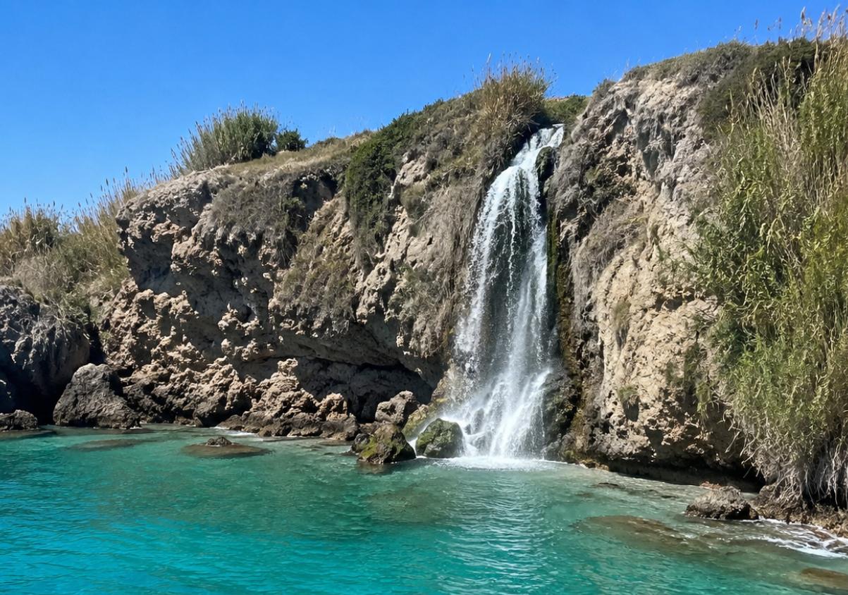
One of the area’s most photographed landmarks is where freshwater drops directly into the Mediterranean.
The Maro waterfall, often known as Cascada Grande, can reach around 15 metres in height and is at its most impressive after periods of rainfall, when the flow increases.
Because of its location beneath the cliffs and limited access from land, many visitors approach it from the sea by kayak or paddleboard.
The route also offers a chance to discover caves, rocky formations and sections of coastline that are almost impossible to appreciate from the viewpoints above.
The waterfall’s appearance varies considerably depending on recent rainfall, so its flow is not always the same.
Historic watchtowers reveal a time when the coast had to be defended
The viewpoints overlooking Maro were not always used simply to admire the scenery.
For centuries, this coastline formed part of a defensive network designed to warn local communities about possible attacks and incursions from the sea.
Several historic watchtowers survive in the area, including those at Maro, Río de la Miel, El Pino and La Caleta.
Their elevated positions provided commanding views over large stretches of coastline and allowed warnings to be passed from one defensive point to another.
Today, they are an important reminder that this peaceful-looking coast once had a strategic role very different from its modern tourist identity.
Maro was once shaped by sugar cane
The landscape also has an important agricultural and industrial history.
For centuries, the area around Maro was closely associated with the cultivation of sugar cane, an industry that played a major economic role in this part of the Axarquía.
Traces of that period can still be found today.
The remains of the old Maro sugar mill recall an industry that employed generations of local residents, while other structures were built to transport the large quantities of water needed for plantations and factories.
The Eagle Aqueduct looks Roman — but it is much younger
One of the most recognisable landmarks nearby is the Acueducto del Águila, or Eagle Aqueduct, located between Nerja and Maro.
Its appearance can easily make visitors assume it dates from Roman times, but it is actually much more recent.
It was built in the 19th century to carry water to the San Joaquín sugar factory.
Its four levels of arches and dramatic position above a ravine have made it one of the area’s most distinctive monuments.
Despite its historic appearance, the aqueduct continues to be associated with water distribution for agricultural use.
Nerja Cave adds thousands of years of human history
Just a short distance from the cliffs lies another of Málaga province’s great natural attractions: the Nerja Cave.
Its archaeological importance shows just how long humans have lived in this part of the coast.
Inside the cave, researchers have found evidence of prehistoric occupation, burials and numerous markings and representations created by different communities over thousands of years.
A visit to the area therefore allows travellers to move in only a few kilometres from prehistoric caves to defensive towers, 19th-century industrial heritage and a protected natural coastline.
El Cañuelo, Maro and Cantarriján: different beaches within the same landscape
Anyone simply looking for a swim will still find some of the most attractive beaches on the eastern Costa del Sol.
Maro Beach sits beneath the cliffs and is a popular starting point for kayak routes.
El Cañuelo, within Nerja municipality, is known for clear waters and seabeds particularly suitable for snorkelling.
Further east, on the Granada side, lies Cantarriján, another well-known beach surrounded by mountains and a relatively secluded natural setting.
Each beach has its own character, but they all share a stronger connection with nature than many of the more urbanised coastal resorts nearby.
A place to explore from land, sea and underwater
One of the best things about Maro-Cerro Gordo is that it can be experienced from several different perspectives.
From land, viewpoints and walking routes reveal the scale of the cliffs and lead towards historic towers.
From the sea, the landscape changes completely, with caves, vertical rock walls and hidden sections of coastline appearing beneath the cliffs.
Underwater, there is yet another world to explore, particularly for snorkellers and divers.
For that reason, the best way to discover the area is not necessarily to choose one beach and stay there all day, but to combine several different experiences.
Why is Maro-Cerro Gordo protected?
The importance of the area lies in its combination of marine and terrestrial ecosystems, together with its landscape and biodiversity.
It was declared a protected Natural Area in 1989 and has since been included within several European and international conservation frameworks.
These include the Natura 2000 network and its recognition as a Specially Protected Area of Mediterranean Importance.
These protections also mean visitors need to respect conservation rules, particularly regarding marine activities, anchoring, fishing and access to certain areas.
A different side of the Costa del Sol
Maro-Cerro Gordo proves that Málaga’s coastline can offer something very different from promenades, large hotels and wide urban beaches.
Here, the scenery is dominated by cliffs, small coves and mountains descending directly into the sea.
What makes the area particularly interesting, however, is everything surrounding that landscape: watchtowers that once guarded maritime routes, remains from the sugar industry, a 19th-century aqueduct, prehistoric caves and a marine ecosystem that represents much of the area’s true ecological value.
So the next time you visit Nerja, it is worth seeing Maro differently: not as a single famous beach, but as an entire landscape stretching from the mountains to several metres beneath the Mediterranean.
Full information on the area’s size, protected status, biodiversity and natural features can be found in the official profile of the Maro-Cerro Gordo Cliffs Natural Area published by the Andalusian Regional Government.

Latest news



Upcoming events
17
Sep
La Pequeña Cuba Gastro-Cultural Festival in San Pedro Alcántara 2026
18
Sep
World Wellness Weekend Marbella 2026
18
Sep
Candlelight: Queen vs. ABBA in Málaga
18
Sep
Candlelight: Coldplay and Imagine Dragons in Málaga
18
Sep
3 de Corazones – Pancho Céspedes, Enrique Ramil and José Luis Jaén in Málaga